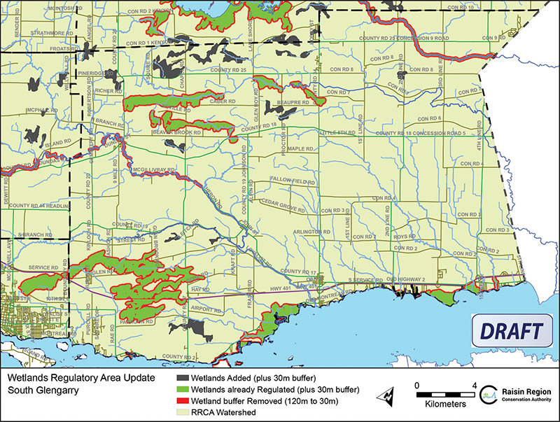
Wetland Update South Glengarry Draft Map
Courtesy Photo
SDG – Only hours before some sessions were to begin, South Nation Conservation (SNC), Rideau Valley Conservation Authority (RVCA) and the Raisin Region Conservation Authority (RRCA) have postponed information sessions seeking public input on updated development policies and wetland mapping used in Conservation Authority permitting.
The Government of Ontario, on April 1, 2024, replaced individual Conservation Authority Regulations under Section 28 of the Conservation Authorities Act, with Ontario Regulation 41/24: Prohibited Activities, Exemptions and Permits. The update requires Conservation Authorities to regulate development activities within 30 metres of all wetlands, as defined by the new regulation.
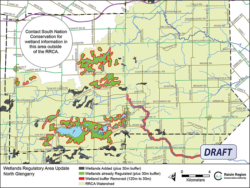
Wetland Update North Glengarry Draft Map
Courtesy Photo
Conservation Authority staff have completed draft updates to policies, procedures and mapping in response to these changes. The information sessions were planned to allow Watershed residents to schedule individual meetings (in-person or virtual) or attend the public open houses to learn more about proposed development policy updates and wetland mapping and to share their opinions. The locations and dates of the public open houses were as follows:
Civitan Club of Perth, 6787 County Road 43, Perth, Ontario on Thurs., June 20, 2024 from 3:00 p.m. – 8:00 p.m. (RVCA)
R.J. Kennedy Community Centre, 1115 Dunning Road, Ottawa, Ontario on Tues., June 25, 2024 from 3:00 p.m. – 8:00 p.m. (RVCA/SNC)
Rideau Valley Conservation Authority Administrative Office, 3889 Rideau Valley Drive, Manotick, Ontario on Wed., June 26, 2024 from 3:00 p.m. – 8:00 p.m. (RVCA/SNC)
South Nation Conservation Administrative Office, 38 Victoria Street, Finch, Ontario on Thurs., June 27, 2024 from 3:00 p.m. – 8:00 p.m. (SNC/RRCA)
In a message that was shared by some municipalities, including North Dundas, the Rideau Valley Conservation Authority (RVCA) advised that RVCA, South Nation Conservation (SNC), and Raisin Region Conservation Authority (RRCA) are pausing consultation on updated wetland mapping, adding that Over the coming months, the conservation authorities will work with ministry staff, municipalities and stakeholders to develop a local approach.
No reason was given for the cancellation.
When the information sessions were originally planned, a joint press release was made stressing the value of Wetlands and how they provide significant ecosystem services and benefits including flood attenuation, erosion protection, groundwater recharge, filtration of drinking water supplies, wildlife refuge, and forest cover, as well as recreational, educational, and research opportunities.
The Conservation Authority partners have regulated development activities within Provincially Significant Wetlands and certain Locally Significant Wetlands since 2006. With the new provincial regulation, most wetlands will now be regulated, however, the buffer around them where a development permit is required has been reduced from 120 metres to 30 metres.
“We recognize the important role of wetlands for the environment and our communities,” said SNC Managing Director, John Mesman. “We will work closely with property owners looking to develop their properties to help confirm wetland boundaries to ensure that future development is sustainable and protects the integrity of wetland habitat.”
“Many of the wetlands in our region connect to major waterways and are found within our Natural Heritage Systems,” said RRCA General Manager Alison McDonald. “These areas provide important natural cover, wildlife habitat, and mitigate the impacts of climate change, including flooding and drought.”
“Having updated policies and wetland mapping that reflects the new legislation will also streamline approvals and standardize approaches,” said RVCA General Manager Sommer Casgrain-Robertson. “Policies and mapping are used by staff, municipalities, and property owners to ensure that development is undertaken in a way that protects people and their property from natural hazards while also protecting wetlands and watercourses.
While it will probably be updated, current policy information, draft maps and meeting request links are available online:
- SNC: www.nation.on.ca/consultations
- RVCA: www.rvca.ca/regulations-planning
- RRCA: www.rrca.on.ca/permits
Conservation Authorities work on behalf of their member municipalities to help manage, conserve and restore natural resources and guide sustainable development activities through permitting.


